Story
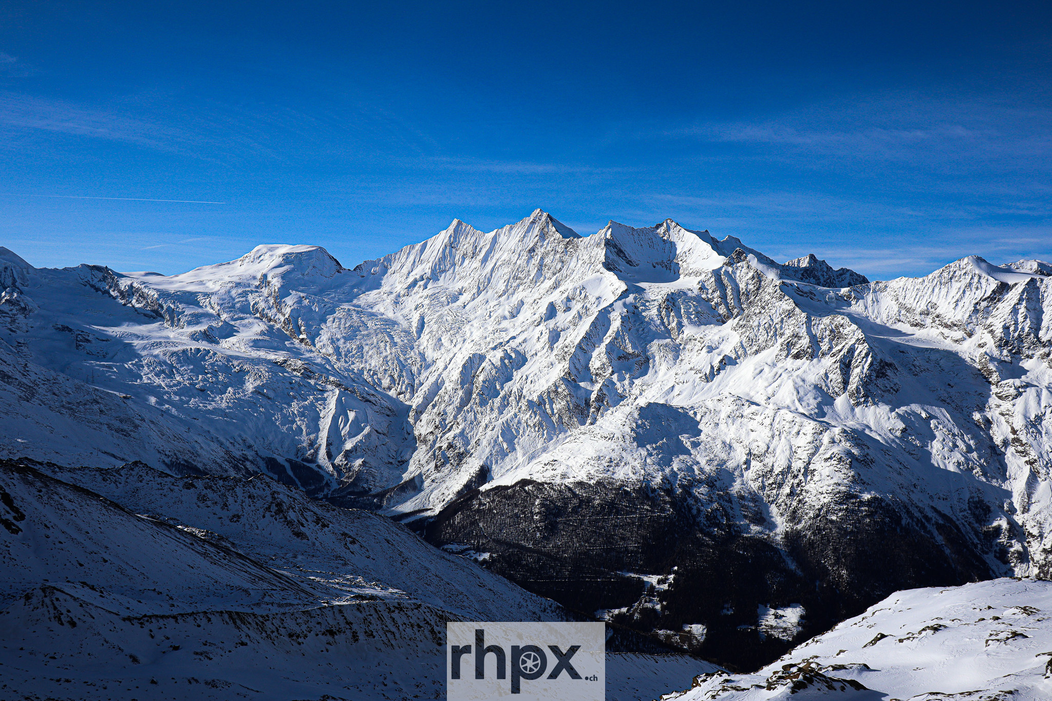
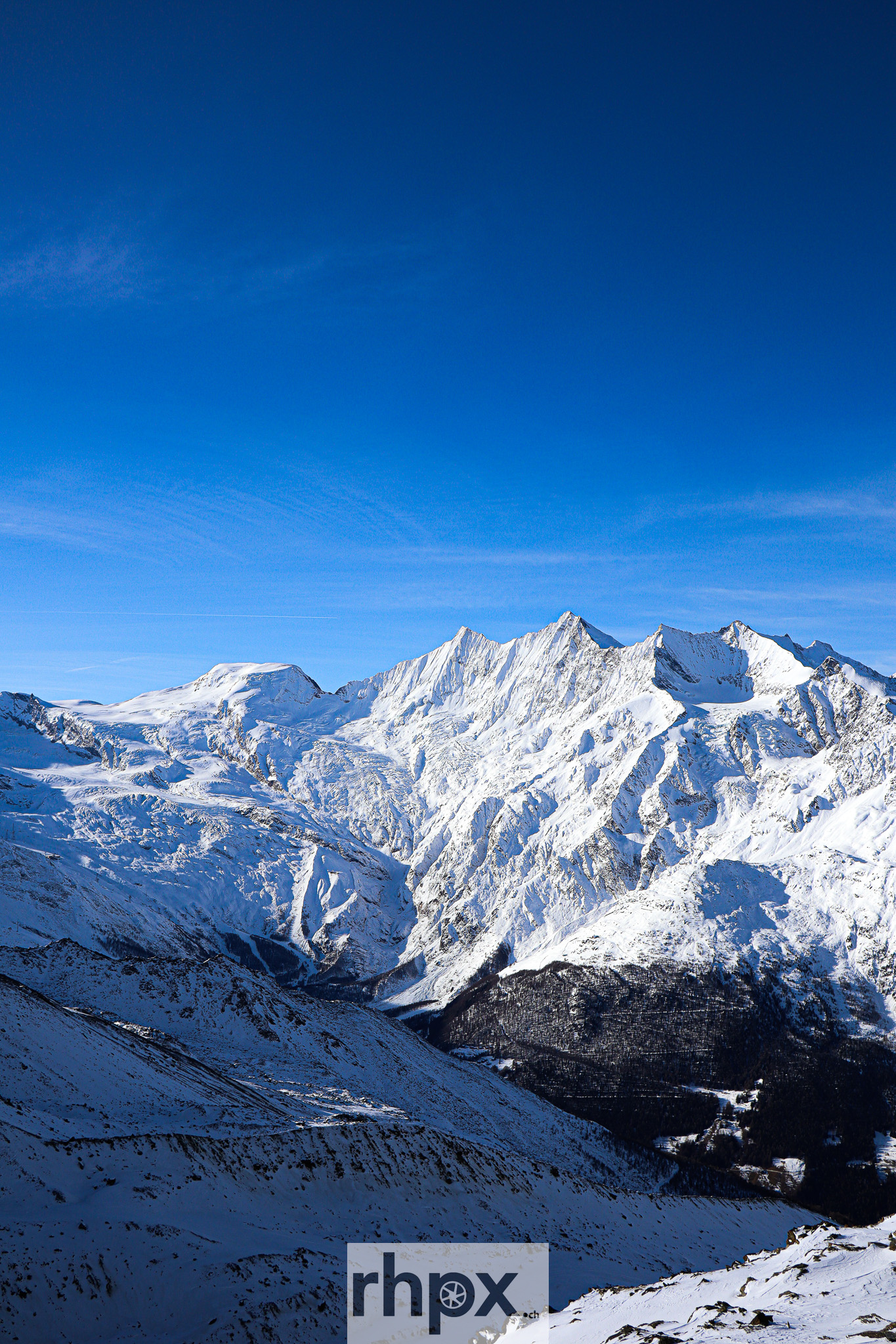
Dom, Lenzspitze, Nadelhorn and Ulrichshorn
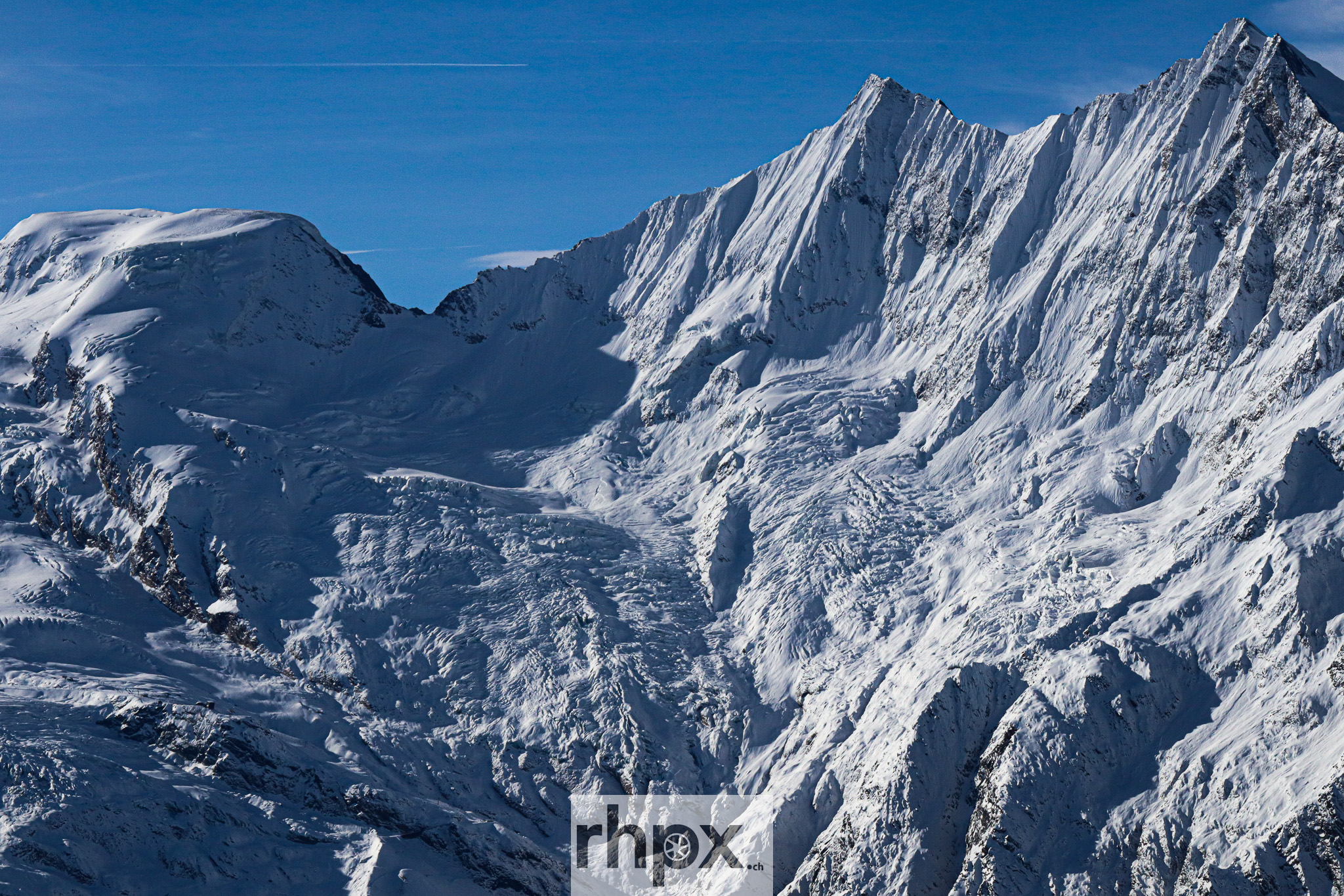
Four peaks of the Mischabel range, all in one image. Dom (4545 m), Lenzspitze (4293 m), Nadelhorn (4327 m) and Ulrichshorn (3925 m).
The Mischabel range lies west of the Saas Valley in the Valais Alps and, after Monte Rosa, forms the second-highest mountain massif in Switzerland. In winter, when the air is clear and the snow sharply defines the ridges, the structure of the individual peaks becomes visible: steep faces, firn, glaciers and ridgelines.
The four peaks in the image
Dom (4545 m above sea level) is the highest mountain located entirely on Swiss territory. Lenzspitze (4293 m) appears as a sharp pyramid with steeply falling flanks; its northeast face is one of the most distinctive wall structures of the Mischabel range. Nadelhorn (4327 m) rises above the surrounding ridges with its pointed summit; its name comes from the “Nadelloch”, an oval rock opening near the summit. Ulrichshorn (3925 m) lies southwest of the Windjoch and offers a direct view of the northeast face of Lenzspitze.
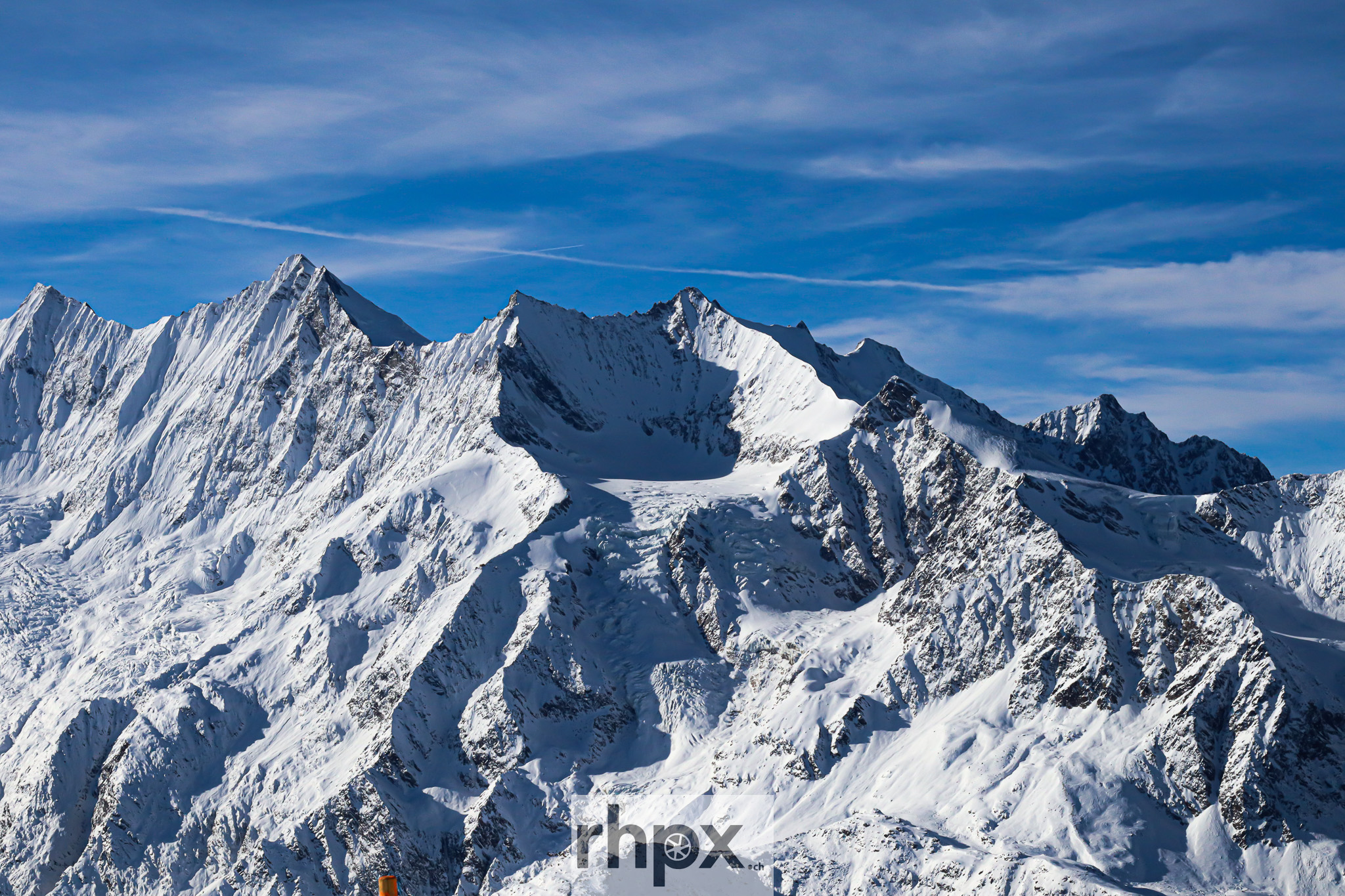
Dom, Lenzspitze, Nadelhorn and Ulrichshorn in winter
Dom, Lenzspitze, Nadelhorn and Ulrichshorn are among the most impressive subjects in the Valais Alps. In their winter appearance, they feel not only high alpine but also graphic: lines, shadows and snowfields shape the image more strongly than individual details.
Dom, the highest mountain entirely in Switzerland
At 4545 m above sea level, Dom is the highest mountain whose entire base lies within Switzerland. The Dufourspitze in the Monte Rosa massif is almost 90 metres higher, but it is a border summit with Italy. Dom received its name from Joseph Anton Berchtold, the canon of Sion, who was the first to survey the Mischabel range in 1833. The first ascent took place on 11 September 1858, when John Llewelyn Davies reached the summit with the guides Johannes Zumtaugwald, Johann Kronig and Hieronymous Brantschen via the northwest ridge. From the east, looking from the Saas Valley, Dom appears as the central summit between Täschhorn and Lenzspitze above the more than one-thousand-metre-high Mischabel wall.
Lenzspitze, a pyramid with sharp ridges
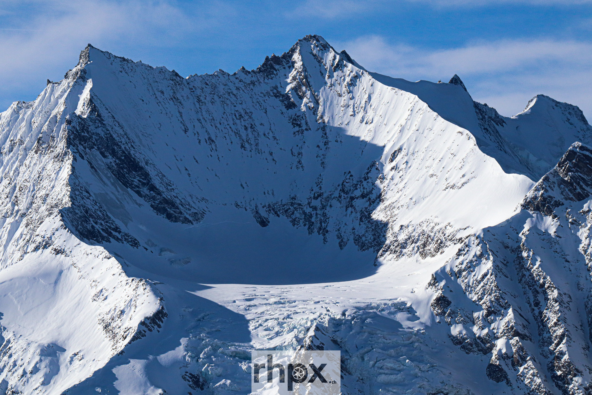
Lenzspitze measures 4293 m above sea level and belongs to the Mischabel in the narrower sense, together with Dom and Täschhorn. It is also known as Südlenz. The northeast face of Lenzspitze is one of the most distinctive wall structures of the entire Mischabel range and can be seen directly from Ulrichshorn. The first ascent was made in 1870 by Clinton Thomas Dent with the guides Alexander and Franz Burgener. Today, the normal route via the south ridge from the Dom Hut through the Lenzjoch is the most common ascent. The traverse from Lenzspitze to Nadelhorn along the Nadelgrat is considered one of the finest ridge tours in the Valais Alps.
Nadelhorn, a pointed summit above the Nadelgrat
At 4327 m above sea level, Nadelhorn is the fourth-highest summit of the Mischabel range. Its name comes from an oval hole in the rock, the so-called Nadelloch, located around ten metres northwest of the summit. Three ridges meet at Nadelhorn: from the northwest via Stecknadelhorn, from the northeast via the Windjoch and from the southeast via Lenzspitze. The first ascent took place on 16 September 1858 by Franz Andenmatten, Baptiste Epiney, Aloys Supersaxo and Joseph Zimmermann, making it one of the few Valais four-thousanders first climbed by local mountaineers. The normal route leads from the Mischabel Hut across the Hohbalm Glacier into the Windjoch and then along the northeast ridge.
Ulrichshorn, a viewpoint above the Windjoch
Ulrichshorn stands at 3925 m above sea level southwest of the Windjoch. It is not a four-thousander, but it is a rewarding summit: from here, the northeast face of Lenzspitze is visible directly and in its full extent. The view also reaches far beyond the main Alpine ridge to the southeast, while to the north the Bernese Alps can be seen across almost their entire west-east extent. The first ascent was made in 1848 by the Swiss alpinist Melchior Ulrich, after whom the mountain is named. Ulrichshorn is often added as an extra summit during the descent from Nadelhorn.
The Mischabel range in Valais
The Mischabel range is one of the most impressive mountain landscapes in the Swiss Alps. Especially in winter, the forms of the peaks stand out clearly. Ridges draw sharp lines, snowfields calm the flanks, and glacier structures become visible in the side light. For photography, this creates a landscape that feels both powerful and reduced.
Photographic perspective
I like how calm this series feels despite the scale of the landscape. The snowfields reduce many details, while ridges, shadows and glacier lines guide the eye. The result is a clear alpine visual language that does not need to be loud to feel present.
More from this series
More Alpine photographs from the Mischabel range, the Saas Valley and the Valais Alps are available in the gallery on rhpx.ch. The images in this series are available as digital downloads, posters and prints on acrylic glass, aluminium Dibond, canvas and FineArt paper. Image licences for editorial and commercial use are available on https://shop.rhpx.ch/2246670/schweizer-berge .
Image selection for this story
More photographs from this series are available in the complete gallery.
View the complete gallery